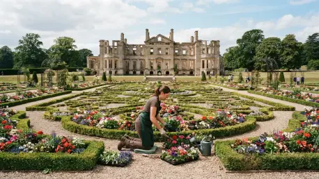

By analyzing the chemical and thermal differences in the lawn’s turf, researchers have identified the exact scale of ornamental features that have been missing for 80 years. Witley Court, located in the heart of Worcestershire, stands as a haunting yet magnificent testament to Victorian opulence that was tragically interrupted by a devastating fire in 1937. Once the palatial home of the 1st Earl of Dudley, the estate functioned as a hub for the elite, showcasing a level of luxury that few could rival. While the skeletal ruins of the mansion and the massive Perseus and Andromeda fountain have remained iconic fixtures, the intricate bedding schemes that once defined the grounds were slowly reclaimed by the natural environment. The current initiative by English Heritage represents a sophisticated effort to bridge the gap between this tragic past and a restored future. By combining archival research with modern investigative techniques, the project seeks to revive the exuberance of the original design, ensuring that the lost artistry of the Victorian era is once again visible to the public.
Unearthing History Through Modern Technology
The integration of high-resolution remote sensing and ground-penetrating analysis has fundamentally changed how heritage organizations approach the management of historic landscapes. At Witley Court, this technological shift enabled a transition from speculative gardening to precise historical reconstruction, ensuring that every new plant placed in the ground aligns with the original vision of the 19th-century designers. This methodology is particularly relevant in the current era of climate volatility, where traditional archaeological methods may be too slow or invasive to capture ephemeral evidence like parch marks. By prioritizing non-destructive techniques, the project has established a new standard for living archaeology, where the goal is not just to document the past but to actively re-engage with it through horticultural excellence. This overarching strategy provided the framework for the specific aerial and physical investigations that followed, allowing the restoration team to move forward with a high degree of confidence in their spatial data.
Capturing Blueprints: The Role of Aerial Observation
The deployment of drone technology served as a critical turning point in the effort to map the estate’s complex history. These unmanned aerial vehicles were equipped with specialized sensors capable of identifying subtle variations in vegetation health that would otherwise be lost to the naked eye. As the drones traversed the Great Witley lawns, they documented the precise geometry of the Victorian parterres, which had been meticulously planned to be viewed from the mansion’s upper terraces. This blueprint from the sky provided a level of accuracy that was previously unattainable, allowing the restoration team to align historical sketches with the actual physical reality of the terrain. The resulting data set offered a comprehensive view of how the garden’s layout interacted with the estate’s grand architecture, serving as a status symbol that emphasized the wealth and social standing of the Earl of Dudley. This intersection of environmental phenomena and technological innovation allowed for a non-invasive resurrection of a landscape thought to be lost.
The science behind these discoveries relied on the differential growth rates of grass when subjected to extreme environmental stress. During recent heat waves, the soil above buried stone foundations and gravel paths dried out significantly faster than the deeper, unobstructed soil in the surrounding lawn. This resulted in the grass browning prematurely in very specific patterns, effectively creating a thermal map of the 19th-century garden. While these parch marks were virtually indistinguishable to observers on the ground, high-resolution drone imagery captured the embroidery parterres in stunning clarity from above. This remote sensing capability allowed English Heritage to identify the intricate French-style scrollwork that William Andrews Nesfield originally designed to frame the Perseus and Andromeda fountain. By utilizing this window of opportunity provided by the changing climate, researchers avoided the need for invasive digging across the entire estate, preserving the integrity of the site’s complex archaeological layers.
Validating Finds: Precision Through Physical Excavation
A week-long geophysical survey and physical excavation provided the necessary grounding for the aerial data, confirming the sheer magnitude of the estate’s horticultural ambition. Archaeologists discovered that a single flowerbed in the East Garden measured an impressive six meters in width and eighteen meters in length, a footprint comparable to a modern residential home. These excavations did not merely confirm locations but also unearthed physical artifacts that had been hidden since the 1937 fire. Notable among the finds were fragments of patterned Bath stone and the stable bases for large ornamental urns, known as tazzas, which historically provided the garden with essential vertical structure. These physical remnants allowed the team to calculate the exact proportions of the lost masonry, filling the gaps where historical drawings and sketches were either too vague or artistically embellished to be reliable for a precise reconstruction. The discovery of these structural elements underscored the permanence with which the Victorians viewed their temporary seasonal displays.
The successful identification of the parterre footprints allowed English Heritage to finalize a long-term conservation strategy that moved beyond simple maintenance into active historical reclamation. By integrating the physical finds—such as the Bath stone and tazza bases—into a comprehensive digital model, the team provided a template for other estates facing similar horticultural losses. Moving forward, the project transitioned into its practical implementation phase, where the focus shifted to the selection of climate-resilient Victorian plant varieties that could withstand future environmental stress. Preservationists recommended that similar sites adopt this non-invasive drone methodology to assess buried assets before beginning any physical intervention, thereby safeguarding the fragile subterranean record for subsequent generations. This proactive approach ensured that the restoration remained a living entity, capable of educating visitors.