
The sheer scale of modern civil engineering projects often necessitates a radical departure from traditional methodologies to ensure both precision and fiscal responsibility during execution. In North Carolina, the Turnpike Authority is currently redefining these industry standards through a sophisticated pilot program that replaces conventional ground-based surveying with high-resolution aerial monitoring. By deploying autonomous drones equipped with advanced light detection and ranging technology, state officials are gaining an unprecedented level of visibility into the progress of massive infrastructure expansions. This shift toward a digital-first oversight model represents more than just a technological upgrade; it is a fundamental change in how public works departments manage the delicate balance between complex construction schedules, contractor accountability, and taxpayer investment. As the Research Triangle continues its rapid growth, these automated systems provide the critical data stream needed to keep the state’s most ambitious highway initiatives moving forward with surgical accuracy and minimal human risk.
Transforming Infrastructure in the Research Triangle
Regional Expansion: Closing the Interstate Loop
The “Complete 540” project stands as the centerpiece of this technological evolution, serving as a critical ten-mile extension of the Triangle Expressway that will effectively close the outer loop around the city of Raleigh. This multi-billion-dollar endeavor is designed to address the logistical pressures created by one of the fastest-growing metropolitan areas in the United States, where housing developments and commercial hubs are expanding at an relentless pace. By completing the Interstate 540 loop, the North Carolina Turnpike Authority aims to create a seamless transportation network that links suburban communities with the central economic engines of the Research Triangle Park. The integration of high-tech monitoring on this specific stretch allows project managers to oversee vast areas of earthmoving and bridge construction that would be nearly impossible to track manually with the same frequency. This infrastructure is a foundational element for the region’s stability.
Mobility Goals: Enhancing Connectivity and Growth
Looking toward the targeted completion date in 2028, the strategic importance of this highway extension becomes even more evident as traffic volumes are projected to rise significantly across the state’s central corridor. The project is anticipated to drastically reduce travel times for thousands of daily commuters while providing a more reliable route for regional freight and emergency services that currently struggle with existing surface street congestion. By establishing this high-speed bypass, the state is effectively future-proofing its transportation infrastructure against the inevitable demands of a burgeoning population and a tech-heavy industrial base. The use of advanced surveying ensures that the aggressive construction milestones required for a 2028 opening are met with rigorous adherence to engineering specifications. This proactive management style ensures that the public receives the maximum benefit from the project’s investment, transforming the way commuters experience mobility.
Advanced Aerial Surveying and Data Synthesis
Precision Mapping: High-Fidelity LiDAR Technology
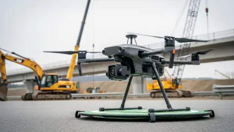
To achieve the high-fidelity mapping required for such a complex site, the agency utilizes the Harris Aerial Carrier H6E drone platform, which is integrated with a high-precision RIEGL laser scanning system. This combination allows for the collection of millions of individual data points per second, creating a dense three-dimensional point cloud that captures the exact topography of the construction zone with sub-centimeter accuracy. Unlike traditional photogrammetry, which can be limited by lighting conditions or dense vegetation, this active sensing technology pierces through environmental obstacles to provide a true ground surface model. These monthly aerial missions transform the construction site into a digital environment, allowing engineers to visualize every embankment, drainage structure, and bridge abutment from a remote location. The resulting data provides a comprehensive record of the site’s physical state at a specific moment in time, offering a level of detail that is unmatched.
Financial Oversight: Integrating Costs and Schedules
Beyond the physical mapping of the terrain, the North Carolina Turnpike Authority has implemented a groundbreaking methodology that links aerial data directly to the project’s financial and scheduling frameworks. This integration of cost-loaded scheduling means that every physical advancement recorded by the drones—such as the exact cubic yardage of soil moved or the precise linear footage of concrete curbing installed—is tied to a specific line item in the budget. By quantifying the work completed through objective digital measurements, the agency can automate the verification process that was previously dependent on subjective manual estimates or self-reporting from contractors. This data-driven approach allows for a highly granular view of how the project’s funds are being utilized in relation to the master timeline. It ensures that the financial health of the project is monitored with the same level of precision as the physical engineering, creating a more disciplined environment.
Maximizing Safety and Project Efficiency
Operational Speed: Advantages of Remote Sensing
One of the most significant yet often overlooked benefits of transitioning to aerial sensing technology is the dramatic improvement in safety for the personnel tasked with monitoring active construction sites. Historically, surveyors were required to traverse rugged terrain and navigate through work zones filled with heavy machinery, high-voltage equipment, and moving vehicles. By utilizing drones to collect topographical data, the North Carolina Turnpike Authority has significantly reduced the need for “boots on the ground” in these high-risk environments, thereby lowering the probability of onsite accidents and injuries. Engineers can now conduct comprehensive site inspections from a safe distance, far removed from the dust, noise, and physical hazards of an active highway project. This shift toward remote monitoring not only protects human lives but also reduces the insurance liabilities and potential work stoppages associated with industrial accidents. It is a more humane approach.
Strategic Evolution: The Future of Digital Management
In the final analysis, the move toward automated oversight demonstrated that the integration of LiDAR and financial scheduling offered a viable solution for increasing the transparency and precision of state-funded projects. This model provided a clear path for other transportation departments to adopt similar technologies, ensuring that complex engineering tasks were performed with a high degree of accountability. To capitalize on these advancements, agencies needed to invest in robust data management infrastructures and prioritize the training of personnel in the use of remote sensing platforms. The pilot program successfully proved that digital twins could mitigate many of the risks associated with large-scale construction, leading to more predictable timelines and better resource allocation. By embracing these innovative tools, the public sector established a more resilient framework for building the transit networks of tomorrow. This initiative underscored the necessity of shifting toward data-centric management.