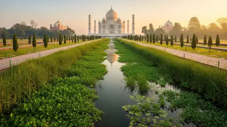

The majestic silhouette of the Taj Mahal, often framed by the ethereal mists of the Yamuna River, faces a persistent and unsightly challenge that threatens the very integrity of its historical setting and cultural significance within the broader landscape of Agra. For decades, the space between this iconic tomb and the Agra Fort has been a site of stalled development and environmental neglect, leaving a scar on one of the world’s most visited heritage sites. A visionary landscape architecture proposal titled “Rethinking Taj Heritage Corridor” now offers a sophisticated roadmap to reclaim this despoiled land. By treating the area not as a static monument but as a living piece of landscape urban infrastructure, the project seeks to dissolve the rift created by failed reclamation efforts. This intervention aims to restore the ecological health of the river while re-establishing the historic visual and physical connections that once defined the Mughal capital. The proposal represents a critical shift toward a holistic management of heritage, where environmental repair and architectural preservation are treated as inseparable goals for the region’s long-term survival.
Historical Evolution: From Mughal Grandeur to Modern Neglect
Agra was originally conceived during the height of the Mughal Empire as a riverfront city where the Yamuna served as the primary ceremonial axis and the lifeblood of urban life. Historically, the riverbanks were adorned with a series of forty-five meticulously designed gardens, each showcasing the empire’s architectural brilliance and its sophisticated mastery of hydraulic engineering. These gardens were not merely private retreats but were integrated into the city’s fabric, providing a rhythmic sequence of green spaces that connected various palaces and tombs. However, this intentional relationship began to deteriorate during the British colonial era and accelerated under the pressure of modern urban sprawl. Bridges, industrial developments, and poorly planned residential blocks gradually severed the city’s connection to its waterfront, turning the once-grand gardens into abandoned relics or disconnected islands of green. This degradation fundamentally altered the visitor’s experience, transforming a cohesive cultural landscape into a fragmented collection of isolated monuments surrounded by urban decay.
The contemporary crisis of the site reached its zenith during a disastrous land reclamation project that intended to create a massive commercial and shopping complex directly adjacent to the Taj Mahal. This project involved dumping hundreds of thousands of tons of debris into the riverbed to create over 320,000 square meters of new land, effectively pushing the Yamuna further away from its historic banks. Work was eventually halted amid a firestorm of controversy and allegations of corruption, leaving behind a barren, “brutal intervention” that permanently disrupted the critical visual corridor between the Taj and the Agra Fort. Today, this stretch of reclaimed earth functions as little more than an informal dumping ground and a repository for untreated sewage, acting as a physical barrier that prevents the river from performing its natural ecological functions. The current landscape proposal recognizes this history of failure and seeks to rectify the damage by prioritizing cultural restoration over commercial exploitation, turning a symbol of political mismanagement into a performative landscape of healing.
Ecological Restoration: Healing the Yamuna Through Green Infrastructure
The Yamuna River is currently embroiled in a regional environmental crisis that has turned it into one of the most polluted waterways in India, particularly as it flows through Agra. Long before the water reaches the city, significant volumes are diverted for agricultural irrigation, leaving the riverbed with insufficient flow to maintain its natural self-cleaning capacity. By the time it passes the Taj Mahal, the river has effectively become a stagnant pool of industrial runoff and raw sewage, which poses a direct threat to the white marble of the monument through corrosive atmospheric emissions. The previous landfill only exacerbated these conditions by trapping stagnant water and disrupting local groundwater cycles. To address this, the proposal introduces a sophisticated hydrological system designed to treat local sewage before it ever reaches the main river channel. This approach moves away from traditional, energy-intensive gray infrastructure in favor of a biological water treatment canal that mimics natural purification processes to ensure a cleaner and more sustainable aquatic environment.
At the heart of the environmental strategy is a recreational water treatment canal that traces the path of the original riverbank, serving as both a functional utility and a public amenity. This canal utilizes a multi-stage purification process that begins with sedimentation and aeration to remove solid waste and increase oxygen levels in the water. Following these initial steps, the water passes through specialized root-zone filtration systems where specific plant species naturally extract heavy metals and organic pollutants. The resulting treated water is then distributed across the site to irrigate the diverse vegetation and productive agricultural zones that form the new corridor. Any excess water undergoes a secondary filtration process through a series of constructed wetlands before it is finally released back into the Yamuna. By integrating this system directly into the landscape, the design ensures that the site functions as a net-positive contributor to the river’s health, demonstrating how urban infrastructure can be elegantly hidden within a lush and productive parkland.
Landscape Integration: Blending Cultural Heritage with Functional Design
The planting strategy for the restored corridor is deeply rooted in the historical aesthetics of Mughal gardens while incorporating modern techniques of phytoremediation to address soil toxicity. A grid system, inspired by the traditional “charbagh” layout, organizes the flora into manageable modules that reflect the grand scale of the surrounding monuments. Designers have selected a palette of plant species derived from existing protected sites, including indigenous flowering trees and fruit-bearing shrubs that boost local biodiversity and provide habitat for native birds. In areas of the landfill where the soil remains heavily contaminated by years of waste dumping, the proposal employs specific plants capable of drawing toxins out of the earth and stabilizing the ground. Furthermore, the design maintains strategic clearings to ensure that the iconic views of the Taj Mahal remain unobstructed, creating a “silently mild” landscape that enhances the viewer’s experience of the monument without competing with its architectural dominance.
Beyond its ecological and aesthetic roles, the proposal reimagines the corridor as a vital link for the local Agra community, which has long been excluded from the riverfront. A primary pedestrian pathway runs alongside the new treatment canal, connecting the northern residential neighborhoods near the Agra Fort to the parklands surrounding the Taj Mahal. This network of walkways transforms the riverfront from a neglected “backyard” into a front-facing civic asset where residents and tourists can interact in a shared public realm. Integrated lookout platforms are positioned at key vantage points, serving as both educational nodes and places of reflection. These platforms allow visitors to observe the coexistence of modern water treatment technologies and ancient historic beauty, fostering a deeper understanding of the challenges facing heritage conservation in the twenty-first century. By providing accessible green space and improved transit options, the project addresses the social needs of a modern city while honoring the monumental history that defines its global identity.
Socio-Economic Viability: Building Sustainable Governance and Phased Transformation
To ensure the long-term success of the intervention, the proposal outlines a collaborative management framework that bridges the gap between international conservation standards and local economic realities. This model involves partnerships between global entities like the World Bank and local governmental bodies such as the Agra Development Authority and the Archaeological Survey of India. Economic sustainability is woven into the landscape itself through the inclusion of productive farmlands that can be managed by local residents. These agricultural zones are designed to grow ornamental plants and traditional crops for sale in local markets, providing a steady stream of revenue for the corridor’s maintenance while offering employment opportunities for landless farmers in the region. This strategy empowers the local community to become active stewards of the site, ensuring that the project remains socially relevant and financially viable without relying solely on government subsidies or tourism entrance fees.
The most innovative and forward-thinking component of the proposal is its temporal strategy, which envisions the eventual removal of the artificial land once the river’s health is restored. As regional initiatives like the Yamuna Action Plan begin to take effect and the river’s natural self-cleaning capacity is improved, the man-made treatment systems within the corridor will gradually become obsolete. The design proposes a phased retreat, where erosion control walls are strategically dismantled to allow the natural monsoon floods to slowly reclaim the landfill over several decades. This process of managed erosion would eventually return the site to its original geography, allowing the Yamuna to once again flow directly against its historic banks. By planning for its own eventual disappearance, the landscape intervention serves as a temporary bridge to a future where the river and the Mughal gardens exist in a state of natural harmony. This approach highlights the importance of flexibility in landscape design, where the ultimate success of a project is measured by its ability to facilitate a return to ecological balance.
The successful restoration of the Taj Heritage Corridor required a departure from traditional conservation methods and a bold embrace of landscape as an active, performative system. By prioritizing the ecological revitalization of the Yamuna River, the project addressed the root causes of urban decay rather than merely masking the symptoms. The implementation of biological water treatment and community-based agriculture provided a template for how other heritage sites in the Global South might manage the conflicting demands of preservation and development. This proposal moved beyond the failed commercial ambitions of the past to create a resilient public space that honored its Mughal origins while serving the modern needs of Agra’s citizens. The phased strategy for landfill removal demonstrated a profound respect for the natural cycles of the river, ensuring that the intervention remained a temporary yet essential step in the site’s long history. Ultimately, the work established a new standard for landscape architecture, proving that the most effective way to protect a monument was to heal the environment that sustained it.