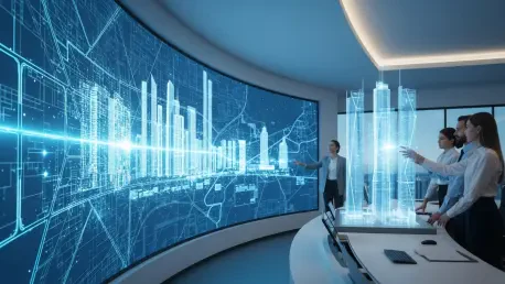

The traditional blueprint, once considered the definitive guide for civic development, has rapidly devolved into a static relic of a bygone era as metropolitan hubs globally replace paper-bound plans with sentient digital ecosystems. For decades, city planners relied on historical data and periodic surveys that were often outdated by the time they cleared regulatory hurdles, leading to infrastructure projects that failed to meet the evolving needs of the public. Today, the advent of Urban Digital Twins has facilitated a fundamental paradigm shift, replacing fixed documentation with live, data-synchronized virtual replicas that mirror a city’s physical state in real-time. These sophisticated models serve as virtual sandboxes, allowing municipal authorities to test high-stakes interventions in mobility and infrastructure without risking public safety or financial resources. By synchronizing the physical environment with continuous telemetry pipelines, planners have moved beyond guesswork and intuition, ensuring that every skyscraper, transit line, or park is validated by rigorous data-driven evidence before the first shovel hits the ground. This evolution has effectively bridged the gap between theoretical urban design and the complex, fluctuating realities of modern metropolitan life, providing a platform where innovation can be simulated, measured, and refined in a risk-free digital environment.
The Technical Foundation: Building Intelligence Into Structure
At the core of a functioning Urban Digital Twin lies a high-fidelity 3D model that encompasses every physical attribute of the city, from the precise height of skyscrapers to the intricate layout of underground utilities. This digital scaffolding is no longer a simple visual representation but a dynamic asset fueled by an relentless stream of data from diverse sources including IoT sensors, high-resolution satellite imagery, and human mobility patterns. By integrating these disparate data streams, the digital twin becomes a living system that evolves alongside the physical city, offering a level of monitoring that was previously unattainable. For instance, sensors embedded in traffic lights and pavement provide a constant pulse of vehicle density, while environmental stations track air quality and temperature in real-time. This continuous feedback loop ensures that the virtual model is never more than a few seconds behind the physical reality it represents, allowing for a granularity of observation that can detect even the most subtle changes in urban behavior, such as shifting foot traffic patterns or variations in utility demand across different neighborhoods.
The true intelligence of these digital cities is derived from artificial intelligence, which acts as the engine converting raw structural data into actionable predictive insights. As modern cities generate staggering amounts of information every hour, manual analysis is no longer a viable option for municipal staff. Machine learning algorithms are essential for processing this data to identify hidden patterns, such as the correlation between specific weather events and localized power grid stress. These AI models use historical data to run thousands of “what-if” scenarios simultaneously, allowing planners to visualize the potential ripple effects of a new development before committing any capital. This shifts the planning process from a retrospective exercise based on past failures to an optimized simulation where the best possible outcome is determined through iterative digital testing. By leveraging deep learning architectures, cities can now anticipate the needs of their citizens, transforming the urban environment into a proactive system that adjusts to demand rather than a reactive structure that struggles to keep pace with growth.
Optimizing Urban Mobility: From Gridlock to Fluidity
One of the most immediate and impactful applications of digital twin technology is found in the realm of traffic management and transit optimization. Urban congestion currently costs major cities billions of dollars annually in lost productivity and wasted fuel, yet digital twins offer a way to simulate and mitigate vehicle movements across an entire metropolis with surgical precision. Planners can now evaluate the effectiveness of proposed bus rapid transit routes or experiment with the timing of traffic signals in a virtual environment to see how they affect surrounding neighborhoods. This ensure that when changes are finally implemented on physical roads, they are proven to reduce bottlenecks and meet the actual needs of commuters. For example, by simulating the closure of a major thoroughfare for maintenance, AI can identify the most efficient detour routes and automatically adjust signal timing on peripheral streets to prevent gridlock. This level of foresight minimizes the economic and environmental toll of urban transit, ensuring that the movement of people and goods remains fluid even during periods of significant infrastructure change or rapid population expansion.
Beyond daily traffic flow, digital twins are fundamentally changing how municipalities handle long-term infrastructure health and predictive maintenance. By embedding sophisticated sensors in critical assets such as bridges, tunnels, and water main systems, cities can feed real-time structural health data directly into their digital models. Artificial intelligence monitors these inputs for signs of fatigue, corrosion, or impending failure, facilitating a transition to a “preventive maintenance” model. This approach allows for repairs to be scheduled and completed before a total breakdown occurs, which significantly enhances public safety while simultaneously saving substantial amounts of taxpayer money that would otherwise be spent on emergency reconstructions. This shift in strategy is particularly vital as cities struggle with aging infrastructure, as it allows for the strategic prioritization of resources toward the most vulnerable structures. By knowing exactly when a bridge requires a minor reinforcement rather than waiting for a structural failure, city leaders can extend the lifespan of public assets and ensure that the foundational systems of the city remain reliable for future generations of residents.
Environmental Sustainability: Addressing the Climate Crisis
As municipalities worldwide set increasingly aggressive goals to combat the effects of climate change, digital twins have emerged as a vital platform for modeling and implementing green initiatives. Planners use these high-fidelity simulations to visualize the potential impact of transitioning to renewable energy sources or the expansion of public parks to mitigate the “urban heat island” effect. These areas of dense construction often experience temperatures significantly higher than their more rural surroundings, and digital models allow leaders to strike a strategic balance between necessary economic growth and environmental preservation. For instance, a city can simulate the installation of solar arrays on every available rooftop to calculate the total energy yield and its subsequent reduction in carbon emissions. Moreover, the ability to model wind patterns and solar exposure at the street level helps architects design buildings that maximize natural cooling and lighting, further reducing the energy footprint of the urban core. This data-driven approach to sustainability ensures that environmental policies are not just aspirational but are grounded in measurable, simulated results that can be tracked and verified over time.
The technology has also become an indispensable tool for emergency response and large-scale disaster management in an era of increasing environmental volatility. By using AI to generate complex simulations based on variables like rainfall intensity, sea-level rise, or extreme wind speeds, emergency personnel can identify vulnerable neighborhoods and critical infrastructure long before a crisis hits. This virtual sandbox allows for the testing of various evacuation routes and the strategic placement of flood barriers without risking a single life. During an active disaster, the digital twin aids in the smart allocation of resources, ensuring that emergency services and supplies are deployed where they are most urgently needed based on real-time situational awareness. For example, if a hurricane triggers localized flooding, the digital twin can predict which roads will become impassable within the next hour, allowing first responders to reroute assets before they are trapped. This capability to anticipate the progression of a disaster in real-time has fundamentally altered the landscape of public safety, turning the digital twin into a central command hub that protects citizens through superior information and rapid coordination.
Governance and Scale: Navigating the New Urban Economy
The creation of a comprehensive, city-wide digital twin requires a robust technical foundation that includes high-performance cloud computing and advanced Geographic Information Systems. However, the collection and processing of such vast amounts of data raise significant concerns regarding privacy, ethics, and data sovereignty. For these systems to be truly successful and sustainable, they must be perceived as tools for public benefit rather than mechanisms for pervasive surveillance. Governments are currently tasked with implementing transparent governance frameworks that prioritize data anonymization and secure management to build and maintain the public trust necessary for long-term operation. This involves establishing clear protocols on who owns the data, how long it is stored, and who has the authority to access specific layers of the digital twin. By prioritizing ethical considerations and ensuring that data is used to improve the quality of life for all residents, municipalities can foster a collaborative environment where technology and civil liberties coexist. This focus on transparency is essential for the democratization of urban planning, as it allows for a more inclusive dialogue between the government and the governed.
While the advantages of AI digital twins were clearly demonstrated in global hubs like Singapore and London, the initial implementation faced significant financial hurdles that initially limited full-scale adoption. The high cost of advanced software, extensive sensor networks, and the specialized talent required to manage these systems often meant that smaller communities lagged behind. However, the maturation of the technology eventually led to more modular and affordable solutions, allowing smaller municipalities to adopt simplified versions focused on specific pain points like energy efficiency or traffic flow. The transition toward data-centric governance successfully shifted urban management from a reactive posture to a proactive discipline that prioritized long-term resilience over short-term fixes. Municipalities discovered that the initial capital requirements were eventually offset by the massive gains in operational efficiency and the reduction in emergency repair costs. By the time these systems reached a state of widespread integration, the groundwork for a new era of autonomous urbanism had been established, ensuring that city planning was forever redefined by the synergy between human vision and machine precision.