
Construction leaders face persistent risks and rising costs, from equipment theft and near misses to delivery delays and compliance gaps.
Geofencing technology offers a practical way to monitor and manage these risks with virtual perimeters that trigger alerts or actions when people or assets cross defined zones. Done well, it improves security, safety, and operational flow across sites and fleets.
This article explains how geofencing works, when it delivers value, what it takes to deploy it and maximize productivity, and how it helps you make data-driven decisions.
What Geofencing Is and How It Works
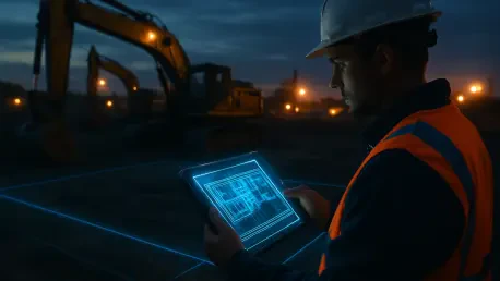
A geofence is a digital boundary placed around a physical area such as a jobsite, laydown yard, or haul road. When a tagged asset, vehicle, or worker with a wearable enters or exits that boundary, the system records the event and can issue alerts or initiate predefined actions.
Site managers can deploy different types of geofences, including:
Polygon geofences, for jobsites and exclusion zones that need precise boundaries
Circular geofences, for setting up boundaries around specific locations and assets
Corridor geofences, for long, narrow zones that typically follow roads or logistics routes
Geofencing in construction relies on a combination of technologies, including GPS or GNSS for wide‑area positioning, Bluetooth Low Energy or RFID for local proximity, and Wi‑Fi or private cellular networks for low-latency data transport.
In steel‑dense structures, tunnels, or urban canyons, solutions often use a location‑agnostic approach that can switch among GPS, Wi‑Fi, RFID, and private cellular to preserve accuracy and uptime.
As soon as a GPS-enabled device, typically attached to the asset, vehicle, or piece of machinery, crosses into or out of a geofenced area, you get a real-time location update.
Depending on the location or even time of the day, any such movement triggers predefined actions or alerts. Alerts can be delivered to supervisors, equipment operators, or worker wearables via mobile apps, audible tones, or haptic feedback to ensure immediate attention.
Geofencing systems with advanced configurations can also slow or disable equipment when unauthorized movement is detected or when a person breaches a high‑risk zone. The following section outlines the key business cases for geofencing in construction.
High‑Value Use Cases on Today’s Jobsites
Geofencing provides an extra layer of visibility and control across multiple jobsites, which has several purposes, from increased security and enhanced safety to better planning and project execution. not only a safety net.
The recent increase in construction crime has put asset security and theft prevention among the key high-ROI applications on jobsites. Think of the last time a piece of high‑value machinery or a variety of power tools disappeared from a site: in most cases, construction crews are not aware of any losses until the next day, and recovery is hardly possible.
Geofencing, however, changes all that. As soon as an asset moves after hours or exits a designated zone, managers or other personnel receive an alert, enabling them to promptly notify law enforcement and aid in recovery. GPS trackers with more robust geofencing capabilities offer even greater control by enabling you to disable the engine through telematics. Overall, the ability to deter unauthorized use and protect capital assets leads to fewer project delays and less rework.
Asset management platforms with built‑in geofencing not only simplify fleet oversight but also enhance safety. If a worker enters a hazardous zone by mistake, a geofence-enabled wearable can issue audible or haptic warnings that restore situational awareness in noisy environments. The more advanced programs detect human proximity to machinery, ensuring the asset automatically slows or stops as soon as a worker is deemed to be at risk.
In other words, deploying geofence systems helps companies enhance their existing safety programs, thereby combating the high number of injuries and fatalities in the sector. Moreover, adopting active geofencing to enforce PPE- or certification‑based access helps maintain a tamper‑proof audit trail for regulators and insurers, even in cases of accidents.
Material visibility and site logistics improve when deliveries trigger automated alerts upon entering a geofenced site. Supervisors can align cranes, crews, and laydown areas in real time, which reduces idle time and bottlenecks.
During execution, managers can allocate equipment and crews based on live movement data, while analytics identify persistent congestion or idle time that layout changes can fix. These movement histories reveal repeated detours or blocked paths, which inform layout changes that shorten transit times.
With all these advantages in mind, building the business case for implementation is straightforward. Baseline incident response times, theft losses, and schedule variance, productivity, then compare post‑deployment. Combine direct gains, such as fewer after‑hours moves and increased operational efficiency, with indirect gains, such as lower insurance exposure and less unplanned downtime, to quantify ROI in terms that executives track monthly.
Technical Requirements and an Implementation Roadmap
Successful programs treat positioning accuracy, low latency, and connectivity resilience as first‑order requirements.
For starters, connectivity can degrade near heavy steel, underground, or in urban canyons, so prioritize tracking platforms that utilize GPS, Wi‑Fi, RFID, and private cellular to maintain a stable fix.
Integration matters as well. Value compounds when geofencing events flow into EHS, asset management, maintenance, and scheduling systems. Many asset tracking platforms include built‑in geofencing, reducing integration overhead, but you also need to ensure compatibility with your existing infrastructure.
In terms of implementation, a phased rollout helps calibrate rules and minimize false positives. Start by defining two or three measurable outcomes, such as a reduction in after‑hours equipment moves, improved evacuation drill times, or fewer near‑misses on a specific site.
Next, map zones that align to these outcomes, using polygon geofences for irregular hazards and corridor fences for haul roads. Set alert thresholds, escalation paths, and enforcement hours per zone to align with shift patterns and site noise levels.
Select technology based on explicit criteria, accuracy, latency, signal fallbacks, device ruggedness, and battery life.
Pilot on a single site or workstream, monitor false alerts, refine fence geometry, and be sure to adjust notifications to avoid fatigue. Train crews and supervisors with simple scenarios that show how alerts prevent incidents, and document the limits of data collection to address privacy concerns.
Once the pilot meets targets, you can use events with EHS and scheduling tools, then expand to additional sites and use cases in waves.
Teams that align technical choices with local site conditions see faster time to value and higher user acceptance.
Conclusion
Geofencing technology transforms construction work on several levels. With its real-time location tracking, it enables companies to protect their assets against theft, reduce safety risk, and uncover key bottlenecks in logistics and layout.
The best results come when precision, latency, and connectivity are engineered for the environment, and you have clarity on the key use cases and KPIs you want to track.
The combination of precise positioning, smart alerts, and measured automation creates a smarter path to protecting people, assets, and margins, while building a foundation for expanding your business.