
The discrepancy between a physical construction site and its digital architectural model often leads to rework costs that can consume up to five percent of a total project budget. This massive financial drain has sparked a fundamental shift in how the geospatial industry approaches data acquisition and processing. Rather than focusing solely on the raw power of laser scanners or the flight time of drones, the current emphasis is on the seamless movement of information. Reality capture now acts as the essential bridge that synchronizes the physical world with digital twins, moving away from isolated, complex hardware toward unified ecosystems. This democratization of high-precision technology allows field crews to generate actionable insights in minutes rather than weeks. By prioritizing the efficiency of the entire workflow over individual tool specifications, the industry is establishing a new standard where precision is accessible, intuitive, and integrated directly into the decision-making process.
Overcoming the Limitations of Fragmented Data Systems
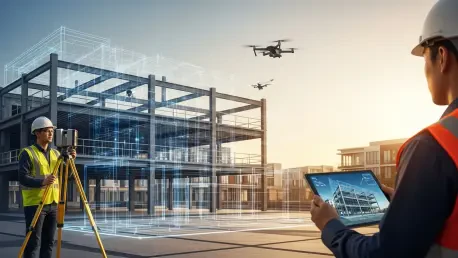
Traditional methods of geospatial data collection historically suffered from a linear and rigid structure where field teams gathered measurements and then physically transported storage drives back to an office for processing. This lag often meant that errors in alignment or missing data points were only discovered days after the crew had left the site, necessitating expensive return trips. Modern workflows have dismantled this siloed approach by implementing real-time verification at the point of capture. By leveraging high-speed connectivity, data now streams directly from the instrument into cloud-based environments and Building Information Modeling platforms. This immediate availability ensures that project managers can validate as-built conditions against design intent while the equipment is still on the ground. Consequently, the window between data capture and strategic decision-making has narrowed significantly, allowing for a more agile response to site-specific challenges.
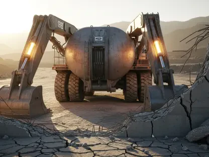
The decentralization of precision tools marks a significant departure from the era when only specialized survey crews could operate reality capture hardware. Today, portable solutions like the Topcon CR-# and advanced smartphone photogrammetry have empowered a broader range of professionals to conduct high-accuracy mapping and verification. This shift does not replace the surveyor but rather extends their reach by allowing utility contractors and site engineers to perform routine tasks with professional-grade accuracy. However, the effectiveness of these decentralized tools depends entirely on their integration into a single, cloud-based ecosystem. Without a unified platform, teams often struggle with incompatible file formats and manual data transfers that introduce human error. A connected workflow removes these technical bottlenecks, enabling field data to be visualized and integrated into existing project models instantly. This accessibility fosters a higher level of transparency across multidisciplinary teams.
Integrating Advanced Visualization and Artificial Intelligence
As the demand for more immersive and understandable data grows, new visualization techniques are augmenting traditional point cloud delivery. While LiDAR remains the primary choice for projects requiring millimeter-level precision, methods such as Gaussian splatting are gaining traction for stakeholder presentations and client-facing models. Unlike the sparse appearance of some point clouds, these newer techniques offer a continuous and aesthetically pleasing surface that provides better context for non-technical viewers. This advancement is particularly valuable when managing digital twins of complex urban environments or historic structures. The ability to switch between high-density geometric data for engineering tasks and photorealistic surfaces for visual inspections ensures that the data serves multiple purposes within the same project. Furthermore, the light footprint of these modern formats allows for smoother navigation of massive datasets on standard mobile devices, bringing the full detail of the field directly into the palm of a project owner’s hand.
The integration of artificial intelligence into reality capture workflows has transitioned from a theoretical possibility to a practical necessity for managing large-scale infrastructure. AI algorithms are now capable of automating the extraction of features from massive datasets, such as identifying utility poles, road markings, or structural anomalies in a fraction of the time required for manual digitizing. This automation is the cornerstone of smart city development, where digital twins must be updated frequently to reflect the current state of the urban landscape. For these AI models to provide reliable predictive analytics, they require training on high-fidelity, real-world data that captures the nuances of actual construction environments. By linking precise geospatial datasets with machine learning, firms can move beyond simple visualization toward proactive maintenance and risk assessment. This shift ensures that the digital representation is not just a static map, but a dynamic tool that anticipates structural failures or traffic patterns based on real-time inputs.
Ensuring Safety and Precision Through Unified Workflows
The practical implementation of integrated reality capture workflows has yielded substantial improvements in safety and operational reliability, particularly in high-risk sectors like utility mapping and tunneling. In subsurface investigations, the combination of handheld capture devices and instant cloud synchronization allowed crews to identify underground hazards before any excavation began. By overlaying real-time field data with existing utility maps, contractors significantly reduced the frequency of accidental strikes, which protected both personnel and existing infrastructure. In the context of tunneling, where complex geometries and confined spaces present unique challenges, linking field data across various industry platforms ensured that structural alignments remained within strict tolerances. This level of precision fostered a culture of confidence among stakeholders, as the data provided an indisputable record of site conditions. The transparency offered by these connected systems reduced the liability associated with fragmented datasets and ensured that safety protocols were grounded in accurate information.
The successful adoption of modernized geospatial workflows required firms to overcome cultural inertia and prioritize continuous education over simple hardware acquisitions. The industry moved toward a model where technology enhanced professional judgment rather than attempting to replace the specialized knowledge of engineers and surveyors. Organizations that thrived were those that implemented robust training programs and partnered with manufacturers to ensure a seamless transition between legacy systems and new digital ecosystems. This shift highlighted the importance of workflow integrity, ensuring that the physical and digital worlds remained perfectly aligned through every phase of construction. Looking forward, the focus remained on refining the interaction between human expertise and automated data processing to maintain high standards of accuracy. By embracing these unified processes, the geospatial community established a foundation for future infrastructure projects that are more transparent, resilient, and data-driven. The commitment to these next steps ensured that every project was backed by reliable, real-time intelligence.