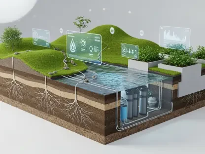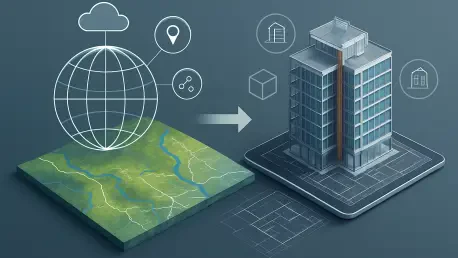

In an era where infrastructure projects are becoming increasingly complex, the need for seamless integration between geographic information systems (GIS) and building information modeling (BIM) has never been more critical, and ArcGIS GeoBIM, part of the ArcGIS Enterprise 12.0 release this November, emerges as a transformative solution. Bridging the gap between architecture, engineering, and construction (AEC) data and geospatial insights, this update—developed through a collaboration between Esri and Autodesk—redefines how multidisciplinary teams approach design, planning, and operations by offering a connected data environment. The promise of enhanced collaboration and streamlined workflows is set to revolutionize project management, addressing long-standing challenges like data complexity and stakeholder communication with cutting-edge tools.
This release stands out by prioritizing efficiency and accessibility, ensuring that professionals across industries can manage intricate projects with greater ease. Imagine navigating massive 3D models without the burden of slowdowns or additional software dependencies—ArcGIS GeoBIM makes this a reality. Beyond technical advancements, the focus is on delivering tangible benefits such as time savings, cost reductions, and smarter decision-making through better data integration. As infrastructure demands grow, this platform offers a timely solution to unify disparate systems into a cohesive framework, empowering teams to achieve superior project outcomes.
Driving Innovation in Data Integration
Revolutionizing 3D Model Handling
The ability to manage large datasets efficiently is a game-changer for AEC and GIS professionals, and ArcGIS GeoBIM 12.0 introduces a beta tool called Add Document Models that addresses this need head-on. This innovative feature allows users to generate simplified 3D models from Revit and IFC documents, slashing file sizes by up to 95 percent. Such a dramatic reduction means that teams can handle and share models without the constant need for high-end software like ArcGIS Pro, thereby cutting down on both time and resource costs. This tool not only simplifies data management but also ensures that critical project visuals are accessible to all stakeholders, paving the way for smoother workflows during the design and planning stages.
Another significant aspect of this tool is its capacity to maintain data integrity while enhancing usability. Models created through Add Document Models remain georeferenced and linked to their source files in Autodesk Construction Cloud, ensuring accuracy and traceability. This connection allows for the rapid creation of 3D web scenes, which are invaluable for presenting project details to clients or collaborators. By facilitating clearer communication and quicker decision-making, this feature helps teams stay aligned on project goals, reducing misunderstandings and delays in critical phases of infrastructure development.
Tailoring Solutions with Advanced Customization
Customization takes a front seat in this update with the introduction of three new widgets—Model Viewer, Link Explorer, and Document Explorer—within ArcGIS Experience Builder. These tools empower users to craft custom web applications tailored to specific project requirements, whether it’s a detailed dashboard for a transportation initiative or a field coordination app for a construction site. The ability to interact with 3D models, explore linked documents, and navigate data folders in a geospatial context transforms raw data into actionable insights, fostering a deeper understanding of project dynamics among team members.
Beyond just building applications, these widgets enhance cross-disciplinary collaboration by breaking down silos between GIS and AEC professionals. Teams can now design interfaces that cater to diverse needs, ensuring that everyone from planners to on-site workers has access to relevant information in a format that suits them. This level of flexibility not only boosts efficiency but also encourages innovative problem-solving, as stakeholders can visualize and interact with project elements in ways that were previously cumbersome or inaccessible. The result is a more cohesive approach to managing complex infrastructure challenges.
Expanding Reach and Accessibility
Enhancing File Compatibility for Diverse Industries
Accessibility in data management receives a significant boost with ArcGIS GeoBIM 12.0 through expanded support for file formats such as JPG, PDF, and DGN. These formats, often critical in sectors like transportation, can now be transformed into collaborative assets within a geospatial framework, eliminating bottlenecks caused by compatibility issues. This advancement ensures that static files become dynamic tools for project coordination, allowing teams to integrate essential data seamlessly into their workflows. By addressing such a fundamental pain point, the platform helps maintain project momentum and reduces the frustration of dealing with disparate file types.
The impact of this update on industry-specific workflows cannot be overstated, as it directly tackles delays often caused by file management challenges. For instance, transportation projects that rely heavily on detailed schematics in various formats can now incorporate these documents into a unified system without needing multiple software solutions. This streamlined approach not only saves time but also enhances the accuracy of shared information, ensuring that all stakeholders are working from the same, up-to-date resources. Ultimately, this fosters better coordination and minimizes errors across project lifecycles.
Bridging Geographic Barriers with Regional Support
Global collaboration is another focal point of this release, demonstrated by the addition of new Autodesk Construction Cloud regions in the UK, Germany, Japan, Canada, and India. This expansion reflects a strong commitment to accessibility, allowing teams worldwide to host and access project data in compliance with local regulations and requirements. By breaking down geographic barriers, ArcGIS GeoBIM ensures that international projects can leverage its robust capabilities without concerns over data sovereignty or connectivity limitations, creating a truly inclusive platform for infrastructure development.
This regional support also facilitates smoother operations for multinational teams by providing localized hosting options that enhance data retrieval speeds and reliability. Projects spanning multiple countries can now operate within a unified system where data access is no longer hindered by location-specific constraints. Such inclusivity means that diverse stakeholders, regardless of their base of operations, can contribute effectively to shared goals. This strategic enhancement not only broadens the platform’s reach but also reinforces its role as a vital tool for fostering global partnerships in tackling modern infrastructure demands.
Empowering Teams for Future Success
Building Skills with Comprehensive Learning Resources
User empowerment through education is a cornerstone of ArcGIS GeoBIM 12.0, with an array of enhanced tutorial resources and insights from industry leaders providing invaluable guidance. These materials delve into both the technical intricacies of the platform’s new features and their practical applications in real-world scenarios, ensuring users can maximize benefits like improved safety and operational efficiency. Catering to a spectrum of skill levels, from novices to seasoned experts, this educational focus equips professionals with the knowledge needed to confidently navigate complex infrastructure challenges using the latest tools.
The inclusion of expert perspectives, such as those from industry figures at prominent firms, adds a layer of practical relevance to the learning experience. These insights highlight how GeoBIM’s advancements translate into measurable outcomes across diverse projects, from urban planning to large-scale construction. By offering a blend of step-by-step guides and inspirational case studies, the platform ensures that users are not just learning how to use new features but also understanding their broader impact. This holistic approach to education strengthens the user community and drives adoption of innovative practices.
Real-World Impact on Infrastructure Challenges
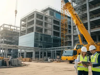
The practical implications of ArcGIS GeoBIM 12.0 are already evident in its application to pressing infrastructure challenges, spanning sectors like nuclear plant construction and urban development. By integrating GIS and BIM data into a cohesive environment, the platform enables teams to address issues of safety, efficiency, and coordination with unprecedented clarity. Real-world examples demonstrate how these tools help mitigate risks and streamline processes, turning complex data into actionable strategies that deliver results on the ground for projects of varying scales and scopes.
Moreover, the ability to visualize and analyze project elements within a geospatial context offers a distinct advantage in decision-making, particularly for high-stakes initiatives. Teams can identify potential issues early, allocate resources more effectively, and maintain alignment across all project phases. This update’s emphasis on transforming data into insights ensures that infrastructure projects are not just completed but optimized for long-term success. As a result, ArcGIS GeoBIM solidifies its position as an indispensable asset for professionals seeking to push the boundaries of what’s possible in their field.
Reflecting on a Milestone Update
Looking back, the release of ArcGIS GeoBIM as part of ArcGIS Enterprise 12.0 marked a pivotal moment in the journey toward seamless GIS-BIM integration. The introduction of simplified 3D modeling tools, alongside customizable widgets, expanded file support, and broader regional accessibility, addressed critical pain points in project management with precision. These enhancements empowered AEC and GIS professionals to collaborate more effectively, turning complex data into clear, actionable outcomes. Educational resources and expert insights further supported users in adopting these innovations, ensuring widespread impact across diverse industries.
Moving forward, the focus should shift to exploring how these tools can be adapted to emerging challenges in infrastructure development. Teams are encouraged to dive into the platform’s capabilities, leveraging its flexibility to create solutions tailored to unique project demands. For those on compatible versions of ArcGIS Enterprise, integrating these features could unlock new levels of efficiency and coordination. This update laid a strong foundation, and the next steps involve building on this progress to drive even greater advancements in connected data environments.