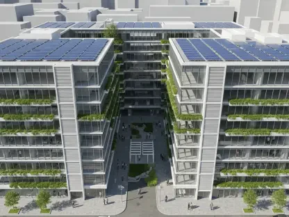

The rapid transformation of Florida’s inland corridors has reached a pivotal moment in Ocala as developers seek to convert hundreds of acres of vacant land into a dense, high-activity urban center. This massive 251-acre mixed-use project, located strategically within the 3000 and 4000 blocks of SW 43rd Court, represents a significant shift in the city’s approach to urban planning and land utilization. Spearheaded by KAS Ocala, LLC, and legal representative Fred N. Roberts Jr., the proposal aims to consolidate various land designations into a single Planned Development. This alignment with the Medium Intensity/Special District vision emphasizes walkable environments and integrated living spaces that contrast sharply with the traditional, sprawling office parks that previously defined the local landscape. As Ocala continues to evolve from a rural equestrian hub into a regional economic powerhouse, this project serves as a test case for how the city balances high-density growth with its established identity. The scale of this endeavor suggests a transformation that will influence local infrastructure for decades.
Architectural Scope: A Blueprint for Massive Expansion
The structural framework of the development is divided into four distinct sections, each designed to serve a specific function within the broader community ecosystem. One 65-acre portion is dedicated to 328 single-family homes, while an expansive 100-acre section could support up to 1,809 units, blending single-family residences with modern multi-family housing complexes. This variety in residential options aims to address the diverse housing needs of a growing workforce, providing high-density solutions that are becoming increasingly necessary in the current economic climate. By concentrating residential units in a unified plan, the developers hope to create a cohesive neighborhood feel that supports local commerce and reduces the reliance on long-distance commuting. The density proposed here is significantly higher than existing neighboring developments, signaling a departure from the low-intensity residential patterns that have historically characterized this part of Marion County.
Beyond the residential clusters, the project incorporates nearly one million square feet of commercial and office space, designed to foster a self-sustaining economic environment. A flexible 28-acre section allows for either additional housing or over 300,000 square feet of professional office space, providing the versatility needed to adapt to market demands as the project progresses. Furthermore, a 54-acre commercial zone is slated for approximately 600,000 square feet of retail and office development, which may include high-profile features such as a large-scale sportsplex or an outdoor entertainment venue. This commercial component is intended to serve not just the residents of the new development but the wider Ocala population, potentially turning this vacant site into a regional destination for recreation and business. The integration of high-density housing with such substantial commercial assets reflects a modern urban design philosophy that prioritizes proximity and functionality over traditional separation of uses.
Infrastructure Impact: Navigating Traffic and Transit Concerns
While the economic potential of such a large-scale development is considerable, the Florida Department of Transportation has raised critical concerns regarding the strain on existing road networks. The influx of thousands of new residents and daily commuters is expected to impact traffic flow significantly on major state-managed arteries, including State Road 200, State Road 40, and the nearby Interstate 75. Transportation officials have emphasized that the existing infrastructure was not originally designed to handle the concentrated volume of traffic that a project of this magnitude would generate. To address these challenges, the Department of Transportation is requesting ongoing coordination with the developers to implement mitigation strategies, such as road widenings or specialized traffic management systems, as the project moves toward its final buildout. This proactive approach is essential for preventing gridlock in one of the city’s most vital transit corridors, ensuring that regional mobility remains viable.
Public sentiment during neighborhood meetings has underscored a deep-seated tension between proponents of growth and long-term residents who value Ocala’s natural character and wildlife habitats. Many community members have voiced strong opposition, citing the potential destruction of wooded buffers and the replacement of green spaces with dense townhomes and apartments. These residents argue that the high-density nature of the project is redundant, especially given existing vacancies in other parts of the city, and fear it will negatively impact property values and local safety. Concerns about privacy are particularly prevalent among those whose properties border the proposed site, leading to calls for stricter requirements for substantial fencing and permanent wooded buffers. This conflict highlights the difficulty of modernizing a city that prides itself on its equestrian identity, as the demand for new housing often clashes with the preservation of the environmental qualities that make the region attractive.
Strategic Governance: Planning for Sustainable Urban Integration
The decision-making process now shifts to the Ocala Planning and Zoning Commission and the City Council, where the focus must remain on harmonizing growth with long-term sustainability. Planners and local officials should prioritize the implementation of strict design standards that mandate significant green space preservation and high-quality landscaping to mitigate the visual and environmental impact of the density. By requiring developers to integrate robust natural buffers, the city can address resident concerns while still allowing for the expansion necessary to support economic health. Additionally, the city council should explore the creation of a comprehensive traffic impact fund, ensuring that the financial burden of infrastructure upgrades is shared appropriately between the private developers and the public sector. This approach would provide a clear pathway for funding the road improvements requested by transportation officials, creating a more predictable environment for all.
Ultimately, the evaluation of the SW 43rd Court proposal highlighted the necessity for a transparent dialogue between municipal leaders, developers, and the public. Stakeholders recognized that successful urban expansion required more than just rezoning; it demanded a commitment to maintaining the ecological integrity of Marion County through innovative architectural solutions. Moving forward, the city council established a framework for periodic infrastructure reviews to ensure that traffic and utility capacities remained ahead of residential occupancy levels. This proactive strategy addressed the immediate fears of the community while fostering an environment where modern mixed-use districts could thrive alongside established neighborhoods. By focusing on actionable mitigation plans and environmental stewardship, the city demonstrated how to manage the complexities of high-density development. The lessons learned from this planning phase offered a clear blueprint for future projects, emphasizing that balanced growth was achievable.