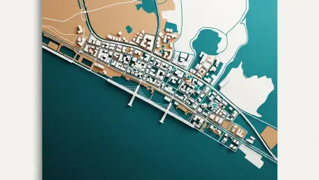

The sudden recalibration of the Lekki master plan has sent shockwaves through the Lagos real estate market, as investors and homeowners scramble to understand how new boundaries affect their property values and development rights. With the official gazetting of these updated geographical limits, the corridor from Victoria Island to Epe is undergoing a fundamental transformation that prioritizes industrial zones and high-density residential hubs over the sprawling, uncoordinated layouts of previous decades. This administrative shift is not merely a clerical update but a radical reimagining of one of Africa’s most valuable coastal strips. The move addresses long-standing issues such as coastal erosion and the encroachment of informal settlements into areas designated for major infrastructure. Consequently, the clarity provided by this redrawing is expected to stabilize land disputes while causing a temporary dip in the valuation of newly restricted lands.
Infrastructure Expansion: Catalyzing Urban Connectivity
The redrawing of the Lekki map specifically accommodates the final phases of the Fourth Mainland Bridge and the expansion of the Lekki-Epe Expressway into a six-lane thoroughfare. By clearly demarcating right-of-way zones, the state government has effectively removed the ambiguity that previously deterred institutional investors from funding large-scale commercial complexes. Areas once considered peripheral, such as the hinterlands beyond the Lekki Free Trade Zone, are now positioned as the next frontier for logistics hubs and tech campuses. This geographic precision allows for a more integrated transportation network, linking the deep-sea port activities directly to emerging industrial clusters without the congestion typically seen in older Lagos districts. As a result, the new Lekki is evolving from a residential suburb into a self-sustaining economic engine where proximity to key transit nodes determines the premium on land prices in this rapidly growing region.
Moreover, the updated map integrates advanced flood mitigation strategies by protecting natural wetlands and creating dedicated drainage corridors that were often ignored during the rapid expansion of previous years. This environmental refocusing means that several areas once marketed as prime real estate are now designated as green zones or water retention basins, forcing developers to pivot toward more sustainable building practices. For the savvy investor, this shift highlights the importance of due diligence; it emphasizes the necessity of compliance with the 2026 zoning laws. The distinction between habitable and protected land has become sharper, leading to a flight to quality where properties within well-planned estates are seeing a surge in demand. This transition ensures that the long-term viability of the peninsula is preserved against rising sea levels, creating a more resilient and attractive urban environment for high-end residential living.
Market Volatility: Navigation for Savvy Stakeholders
The immediate reaction to the revised map has been a bifurcated market where established neighborhoods like Lekki Phase 1 maintain their status, while newer areas face significant price corrections. This volatility is driven by the relocation of commercial permits, which has moved the center of gravity further east toward the refinery and the international financial center. High-net-worth individuals and corporate entities are increasingly looking at these newly designated commercial hubs as safer bets for capital appreciation over the next few years. Meanwhile, the residential sector is seeing a shift toward vertical living, as the new map encourages high-density apartments to maximize the limited dry land available. This density shift is supported by revamped utility layouts, promising more consistent power and water supply to areas that strictly adhere to the new master plan, thereby creating a clear divide between planned and unplanned developments across the peninsula.
Stakeholders who successfully navigated this transition focused on diversifying their portfolios to include land with verified certificates of occupancy that aligned with the new digital map. They prioritized acquisitions in the transit-oriented development zones, where the government guaranteed infrastructure upgrades in exchange for private sector participation. Legal consultants advised a thorough audit of existing land holdings to ensure that all structures complied with the 2026 building codes, which were strictly enforced to prevent future demolition. By embracing the transparency provided by the redrawn map, investors turned a period of uncertainty into a strategic advantage, securing assets that offered long-term resilience against urban decay. This proactive stance allowed them to capitalize on the increased liquidity that followed the formalization of these boundaries. Ultimately, the market matured, favoring those who valued structured growth over speculative gains.